
Site-Level MXD Travel Model
What Does it Do?
The Site-Level MXD Travel model is a tool for assessing trip generation, mode split and VMT for mixed use development. Research done by EPA and others has shown that a mix of uses within close proximity to one another can induce shorter trips and allows residents and employees of an area to drive significantly less if they choose.
How Does it Work?
Technical methods for assessing trip generation have been established by the Institute of Transportation Engineers (ITE). While this has been the gold standard in trip generation for decades and is still in use by engineers across the country, ITE estimates are often based on auto-oriented, single use sites located in a suburban context. The MDX method developed by Fehr & Peers and US EPA provides an alternative measure to the typical ITE estimates by taking into account the potential for "internal trip capture" among uses in close proximity to one another.
Fregonese Associates has integrated this model into Envision Tomorrow's Prototype Builder Return on Investment Model. Now users of the Prototype Builder can quickly assess travel impacts of new development using both the ITE and MXD methods directly in the Prototype Builder excel spreadsheet.
Simply navigate to the "Trip Generation" tab of the Envision Tomorrow Prototype Builder spreadsheet to view model outputs. Calibration requirements range from specifying a detailed use category (restaurant, retail store, medical office, etc) to simply selecting a pre-defined urban context from one of four options (rural, suburban, urban, TOD/CBD).
Required Inputs
The Site-Level MXD Travel Model requires some local data for calibration or can operate based on generic parameters and pre-canned urban context profiles. For full calibration users will need to research the following:
- Average trip lengths for HBW, NHB, and HBO trips in the region/city
- Specific uses within proposed development (restaurant, retail, medical office, etc.)
- Employment accessible within a 30 minute transit trip
- Employment located within 1 mile of the site
- Number of intersections within and on the perimiter of the site
- Presence of transit
- Average household sizes for residents
Using the Model
Site Context

- Number of Intersections: Enter the number of intersections within and directly adjacent to the MXD
- Presence of Transit: Yes/No
- Is the site in a CBD/TOD: Yes/No
- Employment: Enter the employment within 1 mile of the site and within a 30 minute transit trip
- Average vehicles per DU: enter the average vehicles per dwelling unit. Typically the local MPO should have data at the TAZ level, or check the US Census Bureau for data aggregated to Census Block Groups.
Additional Assumptions
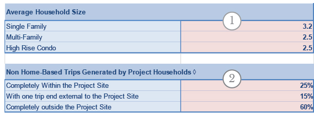
- Average Household Size: Enter the average household size by unit type
- NHB Trips Generated by HHlds: Populated with generic values. Enter locally-calibrated NHB trip rates if available.
Employment Program
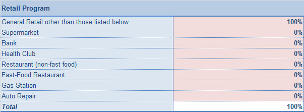
Envision Tomorrow tracks employment in six relatively generic categories (retail, office, industrial, public, education, hotel). The Site-Level MXD requires additional detail about the sub-categories of employment by type that exist in the development.
VMT Assumptions

Enter the HBW, NHB, and HBO trip lengths for the region and the TAZ where the site is located. The local MPO should have this data. If no data is available, use the generic national averages that are populated by default.